Predictive modeling for gold in Minnesota's Archean rocks
I recently completed my MS in GIS, focusing my research on predictive modeling for mineral exploration. Specifically, I used the data-driven weights-of-evidence method to generate new gold exploration targets in northern Minnesota's Archean greenstone belts. The full document can be found here (11 MB pdf).
Before continuing, I must acknowledge the MDNR, MGS, NRRI, and USGS as sources of data and knowledge. The hard work performed by people in these organizations continues to pave the road to discovery for future explorers. A complete list of references is available in the full thesis document, linked to in the first paragraph.
Basically, predictive modeling works by comparing points of known gold occurrences (taken from drillhole records and MDNR till sampling) with evidence drawn from geologic maps, aeromagnetic surveys, and geochemical sampling programs. Spatial relationships are identfied, and from them, patterns useful for exploration are extracted from each layer of evidence. Where multiple patterns coincide, relative prospectivity is high, and where few or no patterns coincide, prospectivity is low.
The end result is a map of northern Minnesota's Archean terranes (excluding the Minnesota River Valley gneiss), ranked from Not permissive to Favorable, in order of increasing relative gold prospectivity. The following figure shows the result of the 'best' model, compared to the six areas of past and present gold exploration focus offered by M. Severson in NRRI/TR-2011/43.
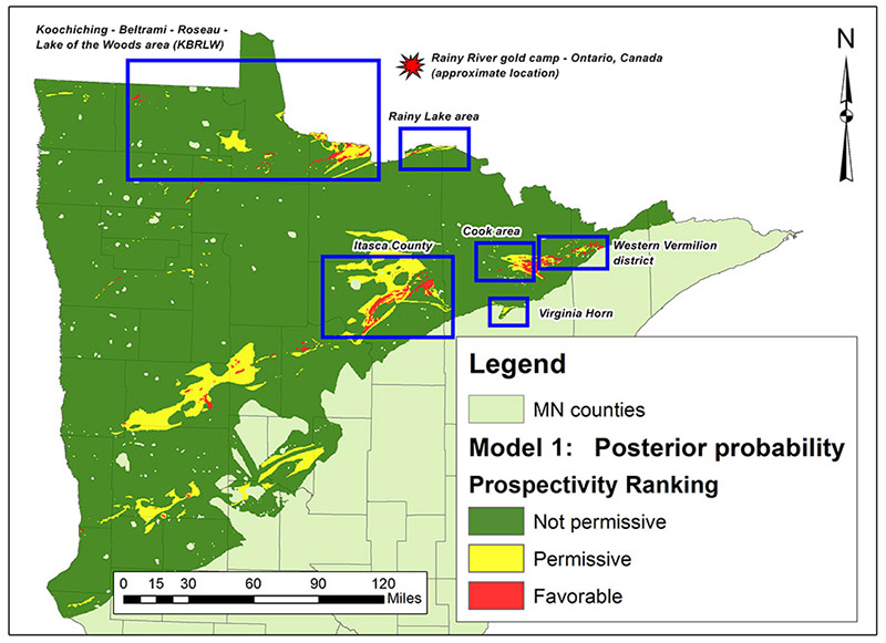
Figure 1: Best model results, relative ranking of study area.
The only area that does not contain Favorable ranks is the Virginia Horn - but this is due to some data inconsistencies and is not an accurate reflection of this area's potential. To the southwest, in Becker and Hubbard counties, there appears to be a new potential gold explration area, although this region is covered by several hundred feet of soil and till - the depth of surficial cover generally increases to the south and west in this part of Minnesota.
Among the key findings of this project is the imporance of Minnesota's high-resolution aeromagnetics, which are available statewide at 1:24,000 resolution.The image below is the result of first using zonal statistics to extract aeromagnetic anomalies, and then testing this anomaly map against points of known gold occurrences. Both high and low magnetic anomalies have spatial associations with gold.
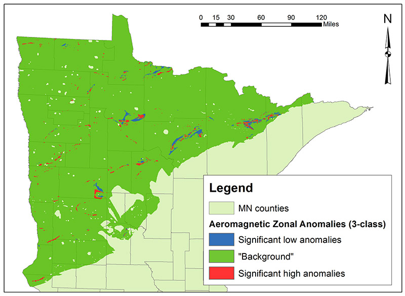
Figure 2: Significant aeromagnetic anomalies in the study area.
Please refer to the full document for further details. I am working with Dr. Gary Raines (USGS, retired) and Dr. Jordan Hastings (USC Spatial Sciences) to publish parts of this paper in a relevant geoscience journal. Links will be provided here upon completion.