Behind the Boom
From the Beginning
The news of oil in North Dakota should not be surprising. Much of western North Dakota overlies a deep sedimentary basin, named after the city of Williston, which is arguably the current epicenter of boom activity. The basin covers some 96,000 square miles, and underlies parts of Montana, Manitoba, Sasketchewan, North Dakota, and South Dakota.
Oil was first discovered in April of 1951 by Amerada Petroleum Corporation, in an exploratory well drilled on a farmstead near the small town of Tioga. One pint of oil was recovered from a drill-stem test, from 10,448' to 10,803' in rocks of Devonian age. Similar discoveries were also made in Manitoba and Montana, in January and July of the same year.
In the years that followed that initial discovery, North Dakota became a madhouse; with oil companies, speculators, and investors grabbing up all the mineral rights they could get their hands on. Hundreds of new wells were drilled, with varying success. Of course, with the discovery also came con-men and shadow companies, who made a lot of big promises to investors but never delivered. The deep geology of the basin was not yet well understood, though several companies, such as Amerada (which is now Hess Corporation), fared well. Hess is still a major player in North Dakota today.
Once the initial 'discovery rush' was over, things slowed down and focus shifted to other, easier oil fields elsewhere in the country, and in the world. This discovery on the frozen plains of North Dakota was 13 years after massive oil reserves were discovered by what was then Standard Oil in Saudi Arabia, which set the stage for the next seven decades (and counting) of incredibly complicated foreign and energy policy for the United States.
But the story of North Dakota's crude really begins much before all of this. About 540 million years before, to be exact, at the beginning of the Cambrian Period and the so-called 'explosion' of life which came with it.
The Williston Basin at that time was nothing more than a depression on the ancient bedrock which makes up a large part of the North American continent. A sort of bowl, if you will, which began filling in with sand, silt, and clay as an ancient ocean began to rise over it. These sediments were buried, compacted, and turned into rock as this ocean advanced. Today, these earliest sandstone and shale deposits are known as the Deadwood formation, and in the deepest parts of the Williston Basin, are now over three miles beneath the surface.
About 50 million years passed by, and the Sauk seas which laid down the Deadwood formation advanced and retreated. But another one soon took its place, and these cycles continued for hundreds of millions of years. Sedimentary basins provide a fascinating record of the past, and the Williston Basin is like a book containing layers of rock as chapters of North America's history. Buried in the rock are fossils, thick layers of volcanic ash, and sediments washed down from the Rocky Mountains as they were uplifted and eroded to the west.
But the chapter of most interest to us today is the one containing the Bakken formation, which is the whole reason for the current boom happening in the first place.
The Bakken Formation: A Primer
The Bakken formation is often referred to as "the Bakken shale," but that's a bit of a generalization. The Bakken is actually composed of three units: two thick, black, organic-rich shales with a sandstone in the middle (even this is a simplified description). The shales were the source of the organic material which thermally matured into oil and gas, and the middle sandstone is the 'sponge' which holds it all.
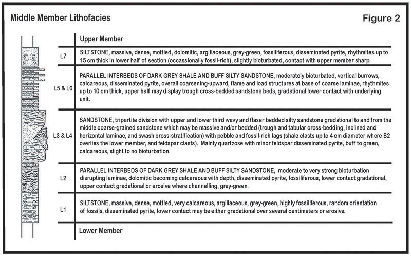
Figure 1: Cross-section of the middle Bakken (Source: 19 MB PDF).
When oil is generated over millions of years in the subsurface, it tends to move around, flowing from its source rock to other rock layers through pore spaces in the rocks themselves. Since oil is less dense than water, and deep basins are often saturated with water at depth, oil tends to migrate upwards until it reaches a layer that it cannot penetrate. These layers are called caps, and every once in a while these caps will be shaped in a way that allows great quantities of oil to gather in small areas.
To illustrate this concept, imagine a sheet of paper lying flat on your desk. This sheet of paper represents a cap layer in the subsurface, with oil milling about underneath. Now imagine that you are pushing the ends of the sheet of paper toward each other - the paper starts to deform, rising in the middle to form a sort of hill. What do you suppose the oil beneath the paper is doing now? It is flowing upward into the rise you have created, concentrating there and forming a rich reserve. What you have just created with the paper is a kind of structural trap, what geologists call an anticline.
Anticlines and other structural traps within sedimentary basins are great places to start looking for oil. There are lots of anticlines in North Dakota, the most well-known being the so-called Nesson anticline, which is home to many rich oil plays. The Nesson runs for miles and miles, from the southeast to the northwest, near North Dakota's western border.
What makes the Bakken special is that most of the oil generated by the shales stayed close to the source, instead of migrating great distances. Above the upper Bakken shale lies several thousand feet of generally impermeable limestone, called the Lodgepole formation. That middle Bakken sandstone provided a convenient reservoir rock for the oil to accumulate in.
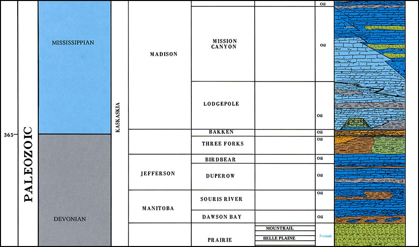
Figure 2: The Bakken and surrounding formations (Source: 54 MB PDF).
Oil has been known to exist in the middle Bakken for decades, but the pore spaces in the sandstone which hold the oil are not very well connected. This means that when a hole is drilled vertically through it, the oil doesn't readily flow out of the formation and into the wellbore, at least not in large enough amounts to be an economically successful well. But two things happened in recent years which started to change the way we look at the middle Bakken.
One was the advance in directional drilling technology and hydraulic fracturing. In a nutshell, wells drilled into the middle Bakken are curved in the Lodgepole, so that when they enter the middle Bakken, they are horizontal. Drilling then advances laterally through the formation, sometimes for up to two miles. All but the lateral section of the hole is then cased with steel and cement, and a mixture of sand and water are forced into the hole at incredible pressure, breaking up the sandstone and creating artificial pathways for the oil to flow into the well, where it is then pumped to the surface.
Then in 2008, the US Geological Survey issued a report on oil resource potential of the Bakken system. The report concluded a comprehensive analysis of the organic content of the upper and lower Bakken shales, and the stable conditions in which the organic material thermally matured into hydrocarbons. The USGS paper stated that 3.6 billion barrels of oil could have been generated by the Bakken system, making it one of the largest oil plays in the country, and sparking a row of optimism about American energy independence.
I won't go into the differences between the amount of oil potentially generated versus amount of oil that is actually recoverable. I also won't cover the issue of America's energy future or the world's dependence on finite energy resources. The important point here is that North Dakota started attracting a lot of attention from oil producers, which began to set the stage for the oil boom we are seeing today.
Welcome to 'Boomtown'
I moved to North Dakota in 2002, to attend school at the University of North Dakota in Grand Forks. My friends and I would venture west every spring, to take in the solitude and the wild, empty feeling of the badlands. It was an annual escape from civilization. The badlands contain hundreds of miles of mountain bike trails, two units of Theodore Roosevelt national Park, and the beautiful Little Missouri River, which created the spectacular badlands when its northerly flow was obstructed by an ice sheet during the last glacial period. A guy could drive for hours without seeing another soul.
Back then, it would have been impossible to imagine how much the landscape would be changing in just a few short years.
Fast forward to late 2009. I was laid off from my first job out of school, assisting with a Tellurium exploration project in Alaska and Yukon. Through a classmate in my geology program, I got a job as a wellsite consultant with Neset Consulting Service, whose home office is in Tioga, near where North Dakota's first oil was struck on that cold spring morning way back in 1951. I had no idea what to expect of oilfield life, in fact I didn't know anything about oil at all when I showed up at Bronco Drilling Rig #8 for my first day of work.
In 2009, as you will see in some of the following maps and charts, the boom hadn't truly started yet. North Dakota had been seeing the number of wells spudded (an industry term for 'started drilling') steadily increase each year since at least 2002 (see Figure 3), but the activity had not really 'exploded' yet. The number of wells spudded actually decreased from 2008, partially due to troubles with the economy and market instability. But by midway through the next year, when I got turned loose to run my own rig, the game had changed entirely.
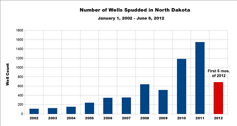
Figure 3: Spudded well counts 2002 - 2012.
The number of wells spudded in 2010 was a record 1,183, a 230% increase from 2009. That record was broken again in 2011, when 1,548 wells were spudded across the western portion of the state. I left my wellsite job in the summer of 2011, partly to go back to work in the mining industry and partly because I just couldn't handle the craziness that was 'Boomtown.'
The economy was still shaky, and thousands of people with nowhere else to go were flocking to North Dakota with hopes of landing a high-paying job in the oilfields. Once half-empty towns were now overflowing, and the cost of rent and real estate skyrocketed. Campgrounds filled up with RV's, hotels were bought out completely, and 'man-camps' of trailers to house workers were popping up everywhere. Still, housing was a major issue, and a lot of people were living in their cars, in tents, in abandoned churches, or anywhere else they could find.
Small communities with little to no police or other services were facing big problems. Roads were being destroyed by heavy truck traffic as fast as they could be resurfaced. New bars and strip clubs were opening up and serving unprecedented numbers of customers, and entertaining ladies were flying in from high-dollar places like Las Vegas because the money in Williston was better. Stores struggled to keep shelves full, and many local businesses were losing good employees to much better-paying oilfield jobs. The Wal-Mart in Williston was flying cashiers and stockers in from all over the country to work rotating shifts, and paying them nice bonuses for their trouble.
The North Dakota that I once knew, and had grown to love, was gone.
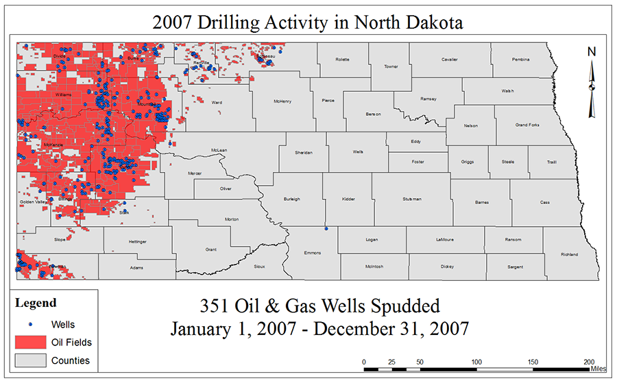
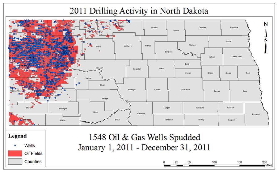
Figs. 4 & 5: Maps showing new well locations for 2007 (left), and 2011 (right).
The maps above illustrate the dramatic increase in drilling activity over a four-year span between 2007 and 2011. Note that this is just North Dakota - the surge of drilling activity is also spreading westward into Montana, and they are hard at work on the Canadian portion of the Williston Basin as well.
Crunching the Numbers
Over the last five years, many new oil companies have moved into the region, and the existing major players have gone into production overdrive. At the time of this writing, there were 191 rigs actively drilling in North Dakota. Many rigs can drill a well in less than 20 days, and then be moved to the next location in under a week. Some rigs can drill as many as eight wells from a single pad. At the time of this writing, one company was planning to attempt a sixteen-well pad!
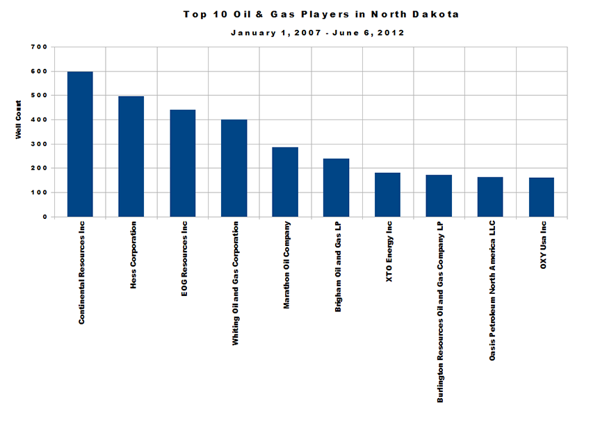
Figure 10: Top ten major players in North Dakota 2007 - 2012.
The production data for 2012 isn't out yet, as it is only September as I write this. But so far, in the last five years, approximately 64,532,910 feet of new hole has been drilled in North Dakota. That is roughly 12,222 miles; or enough to travel from the Montana border in the west to the Minnesota border in the east, and back again, about 18 times.
At the end of 2010, North Dakota's proven crude oil reserves were 1.814 billion barrels, which is about 7.8% of America's proven domestic reserves. The reserve figures for 2011, at the time of this writing, have not yet been released. Also, in 2011 North Dakota became the fourth largest producer of crude oil in the United States, accounting for over 7% of domestic production. North Dakota's production increased about 35% from 2010 to 2011.
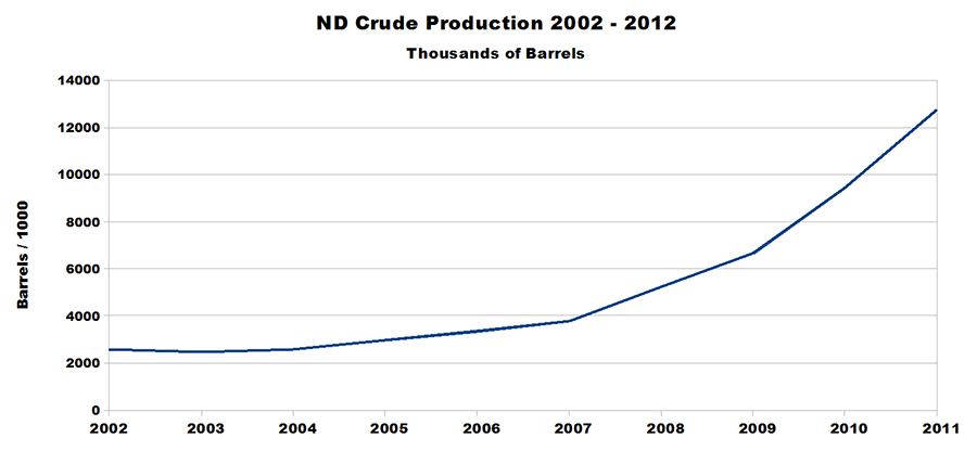
Figure 11: Crude oil production in North Dakota 2002 - 2012.
It should be noted that the Bakken is not the only oil-producing formation in the Williston Basin. It just one of several new plays which are becoming more viable as crude prices rise and experience in horizontal drilling leads to greater efficiency. Other plays have been producing for decades, such as the Mission Canyon and the Red River formations. Just beneath the Bakken, the so-called 'Sanish sands' of the Three Forks formation are also proving to be an incredible resource in some areas. This boom time that we are seeing now may not last forever, but North Dakota will likely remain an important domestic producer for many years to come.
Conclusions and Reflections
Thanks for stopping by. I hope you are able to leave this page with a better understanding of the Bakken oil boom, and a clear picture of the past and present oilfield environments here in North Dakota.
As of two weeks ago, I am back out here again, doing wellsite consulting while I finish my M.Sc. in GIS. Things are different now, a little better, as communities have gained the services they desperately needed and companies have more or less weeded out the people and processes that didn't work. The rig I am following now is staffed by a crew of professional hands, and the improvements in safety policies and procedures in the year I've been gone could be measured exponentially.
I swore I'd never come back to the oilfield life, but here I am. You just can't beat these Boomtown paychecks.
While I am saddened to see the place that brought me so much serenity in its open spaces and empty canyons become an industrial monster, I suppose the change was ultimately inevitable. The night sky is lit by gas flares at wellheads dotting the landscape and the horizon, obscuring a previously breathtaking view of the stars. And today there is so much traffic, at times it becomes maddening.
And not everyone is profiting from the boom; landowners who do not have mineral rights are not collecting royalties from wells drilled on their land. Schools, police, firefighters, and other services are still stretched frustratingly thin in many communities. But overall, the situation today is much better than the situation that I left here in 2011.
As for the question, "Are we doing the right thing?" I don't know. The world needs alternatives to fossil fuels, there is no question about that. With fuel prices rising and showing no signs of stopping, and a global economy which depends heavily on that fuel, the future remains uncertain. But these new oil and gas plays in North Dakota just might buy us a little more time.
Feel free to contact me with questions, comments, or corrections.